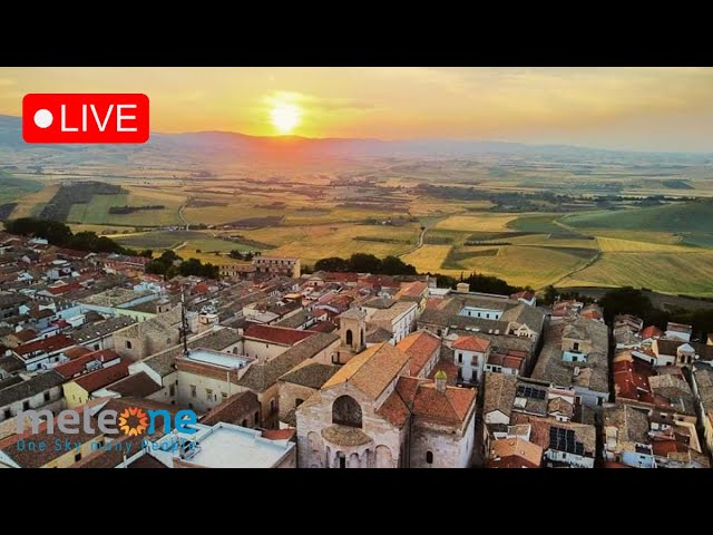
Countryside Panorama over Troia
OnlineA wide 90-degree panorama from the hill town of Troia sweeps across the rolling Tavoliere farmland toward the Gulf of Manfredonia and the distant Gargano promontory. Patchwork wheat fields and a row of wind turbines stretch to a hazy horizon, framed by the rooftops of one of Apulia's most historic villages perched at 420 metres above sea level.
About This Webcam
Everything you need to know about this live stream
A Sweeping View across the Tavoliere
From its perch on the Daunian foothills, this camera captures one of the broadest outlooks in northern Apulia. The Tavoliere delle Puglie, Italy's second-largest plain, unfolds below in a patchwork of cultivated fields that reaches toward the Adriatic coast.
The Gulf of Manfredonia and Gargano
On the horizon the land gives way to the Gulf of Manfredonia, with the rugged Gargano promontory—the 'spur' of the Italian boot—rising beyond it. A line of wind turbines marks the open, breezy ridgelines that define this corner of the region.
The Historic Town of Troia
Troia is celebrated for its Romanesque cathedral and its remarkable rose window, a jewel of medieval Apulian architecture. The terracotta rooftops in the foreground belong to this hilltop settlement founded on the ruins of ancient Aecae.
Agriculture and Renewable Energy
The surrounding countryside is a heartland of durum wheat cultivation, the grain behind Apulia's famous pasta and bread. Alongside the farms, the abundant wind of the Daunian uplands has made the area a centre for renewable energy production.
Location Details
Troia
Troia, Province of Foggia, Apulia, Italy
Europe
Timezone
Rome
Europe/Rome (UTC+2)
GPS Coordinates
41.3636°, 15.3135°
Current Weather
© Open-MeteoInteractive Map - Troia Area

LIVE CAM
Click to Interact
Explore the interactive map
Similar Webcams
Explore other exciting destinations in the same or related category